Sinaw-Al Mutayla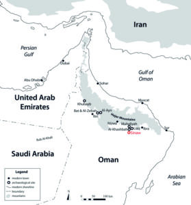
The site is located in the governorate of Shamal Al-Sharqiya, on the northern outskirts of the city of Sinaw and 2 km southeast of the village of Al Mutayla. It is situated on a natural hillock composed of porous calcrete, which is 350 m long, 80 m wide and up to 2 m high. Similar elevated areas in the immediate vicinity appear to be empty, except for a few graves. To the east of the settlement is the main branch of the Wadi Samad, to the west a 10 m high terrace with at least 37 reused Hafit graves from the Iron Age, and behind this the Wadi Andam. To the south, the settlement and the Wadi Samad are cut through by the Sinaw bypass road, which was built in 2017 and has mainly affected the southern part of the site. Gardens and other agricultural land may once have been located here, but these have now been destroyed or built over.
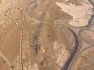
Aerial view of Sinaw-Al Mutayla.
Preliminary work
As part of the Al-Mudhaybi Regional Survey, led by Stephanie Döpper (Goethe University Frankfurt), some pottery was collected from the surface in 2020. Analysis of the ceramics revealed that they date exclusively to the Iron Age, with the vast majority belonging to Iron Age II (1100–600 BC).
From 2022 to 2024, Conrad Schmidt (University of Tübingen) conducted aerial surveys and geophysical prospections. The latter covered the entire hillock and part of the adjacent southern plain. These revealed numerous fireplace remains and confirmed the presence of two square buildings and two unidentifiable structures, including a hexagonal enclosure wall surrounding an open area of approximately 1,600 m². The aerial surveys provided a more detailed picture of the four buildings or structures. The two square buildings are stone structures measuring up to 30 x 30 metres and are comparatively well preserved. One of them contains a well. The outer walls of the buildings and parts of the interior structures are clearly visible in the digital elevation model (DEM).
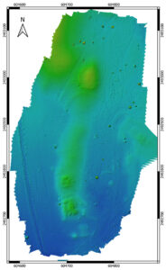
Digital elevation model showing the location of the four large buildings.
The first archaeological excavations in Al-Mutayla took place in 2025. Three squares, each measuring 10 x 10 metres, in Building I in the north of the settlement were excavated. Several fireplaces, a pit filled with ashes, a semicircular stone installation and a large entrance to the hexagonal structure were discovered, as well as Iron Age II pottery and a large number of animal bones. Another test trench was opened to the south of the hillock on which the three large buildings are situated. This revealed a thick layer of ash beneath the current surface, superimposing several stone walls measuring up to 70 centimetres in height. These are referred to as Building IV. The excavations in Building IV also yielded large quantities of charcoal and installations made of organic materials, as well as a significant amount of Iron Age II pottery.
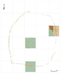
Overall plan of Building I.
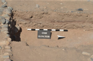
Burned layer in Building IV.
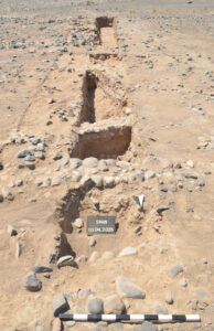
Building IV with numerous stone walls.
Excavations
Since 2026, a team from the University of Tübingen led by Conrad Schmidt is conducting intensive archaeological fieldwork in Al-Mutayla as part of the DFG project „At the fringes of southeastern Arabia’s Iron Age“. This three-year research project will examine the subsistence economy and other features of the Iron Age in Central Oman and compare them with those of sites in the north. The project aims to investigate how societies adapted to their environment, sheds light on the availability of natural resources and anthropogenic environmental changes, and seeks to establish a common chronology for southeastern Arabia. Archaeological work is accompanied by archaeobotanical, archaeozoological, and petrographic analyses. Investigations into soil science are also planned for the area around the settlement, where the existence of gardens with irrigation systems is expected.
During the first campaign, archaeological investigations focused on Building III in the southern part of the hillock. This work uncovered sections of the stone outer wall, which had been buried under a large quantity of collapsed stones and pottery. The latter dates to the Iron Age II period (1100–600 BCE), with the shapes and types of pottery — including numerous painted sherds — suggesting that the building was of a high standard. The dating of the pottery aligns perfectly with the initial 14C measurements of charcoal from Buildings I and IV from last year’s preliminary work, which fall within the period between 790–569 and 767–544 cal BC, corresponding to the final phase of the Iron Age II. Inside Building III, a series of small rooms, preserved to a height of up to 1.80 m, were discovered and partially excavated; they consist of a mixture of levelling courses and rows of mud bricks and are likely to be interpreted as the building’s foundation. Interestingly, the architecture does not appear to continue in the western half of the building, a feature that will be investigated in more detail during the next campaign.
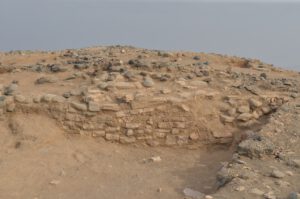
Building III, viewed from the south.
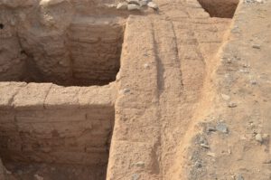
Interior of Building III, featuring well-preserved mud brick architecture.
Besides pottery, various other small finds were unearthed during the excavations, including a heavily corroded axe and four bronze arrowheads (iron was still unknown in southeastern Arabia during the Iron Age), several fragmented grinding stones, a clay animal figurine and fragments of decorated soapstone vessels. There is also a large amount of charcoal from all over the site that helps us to date the building's different phases more precisely and determine the type of wood used in its construction and for making fire.
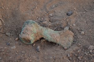
Bronze axe.