Persons responsible:
Tara Beuzen-Waller finished her PhD in Geography at Sorbonne University (France) in 2020, with a speciality in Geoarchaeology. During her PhD she worked in different projects in Oman and in Saudi Arabia and gained experience in Geomorphology and Geoarchaeology. Her special field of interest is the humans-environment relation and the impact of climate change on Omani hydrosystems.
Dana Pietsch works in the project since November 2023 and is researching the paleosoils as part of the geoarchaeological questions. Her research focuses on sediment and soil stratigraphy in the south of the Arabian Peninsula, East Africa and Russia. In particular, she is interested in the relationship between soils and climate change.
Methods applied:
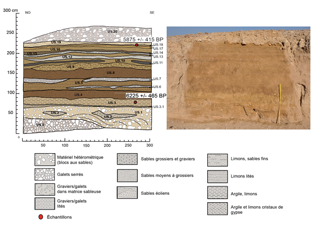 Geoarchaeologists are using methods and tools of geomorphology and geography to answer archaeological questions related to environment, resources, and on-site processes. At the regional scale, geoarchaeologists are working with satellite imagery, ancient maps or aerial pictures and archaeological geodata. They are producing maps to understand the large-scale spatial dynamics for each period. At the local scale, work is on ancient alluvial formation and on hydraulic systems. Alluvial formations are an opportunity to understand current and past flow dynamics. In Oman, they are critical to rebuilt hydro-climatic fluctuations, understand where and when surface flow occurred and question local water resources. The studying of alluvial formations is relying on morphostratigraphy, sedimentological analyses and dating (using radiocarbon or Optically Stimulated Luminescence). The methods of archaeology (stratigraphy, dating, study of anthropogenic materials) are required for the analyses of hydraulic systems. Here the main goal is to date the period of building and functioning of every structure, which is very challenging. In addition to the alluvial soils, other soils occur both within the archaeological structures and in their surroundings. These buried paleosols are often covered by younger sediments and provide information on Holocene climate change. At best, these paleosols, enriched with humus, iron, limestone and artifacts, help to support the stratigraphy of both the fluvial systems and the colluvial deposits. Like the alluvial soils, they are studied sedimentologically and additionally analysed micromorphologically.
In the UmWeltWandel project, the main research question is the impact of the aridification of climate at the end of the Holocene Pluvial Period on hydrosystems and water resources. One of the major goals is to reconstitute the environment before and during the Bronze Age in order to understand how societies exploited or coped with the environment and available resources and how the landscape evolve since. In Oman, the onset of oases during protohistoric times is one of the main topics that researchers are working on in the field of environment-societies relation. Oases are anthropogenic agrosystem, completely artificial, where intensive plant cultivation is sustained by irrigation. Oases are an eloquent example of how humans coped with restrictive environmental conditions and developed after all ingenious and sustainable system.
In the UmWeltWandel project various scales of analyses are used. From a regional scale, geomorphological maps are created using published data, satellite imagery and fieldwork. All the mapping process is realized with a multidisciplinary GIS (Geographic Information System) combining all the spatial data collected. The geomorphological map provides us information about quaternary landforms and spatialization of geomorphological dynamics (slope dynamics, extent of the floodplain, anthropogenic soils etc.). Particularly interesting are alluvial landforms that will be precisely described and dated. From a local scale, the immediate surrounding environment of archaeological sites are studied. The goal is to precisely reconstitute the landscape before, during and after the occupation of the site. In addition, the environmental and geographic potential of the area, the anthropogenic modification/optimization of the site, and the exposure of the site to geomorphological dynamics are looked at. From an intrasite scale, excavations of hydraulic structures, and particularly ditches, are conducted in order to understand how they work and how many times there were used.