“We only borrowed the earth from our children” Environmental changes and the way of life in Central Oman in the 3rd and 2nd millennia BC
To date, the Arabian Peninsula has only rarely been archaeologically explored. Although it is one of the driest regions in the world, its eastern part, which is mainly occupied by the Sultanate of Oman today, had a cultural and economic heyday as early as the 3rd millennium BC. However, it is not yet known how people managed to adapt to the marginal environment at that time. In particular, there is a lack of precise chronological differentiation of environmental changes in Central Oman, especially with regard to the availability of water and vegetation dynamics. It would thus be possible to make connections between people’s way of life, subsistence and failed or successful sustainability strategies, on the one hand, and the fragile environment, on the other.
Funding for the new joint research project began on 11 November 2020 and is provided by the Federal Ministry of Education and Research (BMBF) as part of its funding directive “Kleine Fächer – Zusammen stark”. In the course of the four-year project in which Tübingen and project partners from Mainz, Frankfurt and Göttingen are involved, various natural scientific and archaeological methods are used in order to examine the environmental changes and the way of life of the people in Central Oman in the 3rd and 2nd millennia BC. In addition, comprehensive data on the environmental conditions are collected and evaluated as well as linked to known historical events that took place during this important period. The multi-proxy approach of the project includes the analysis of phytoliths, pollen, seeds and charcoal to determine the flora, the study of snail shells, which provides insights into seasonal changes in precipitation and temperatures, as well as geomorphological analyses that compile the development of environmental resources, especially water, and the adaptation of society thereto. Human intervention in the ecosystem and thus the interaction between humans and their environment also play an important role. The results of the joint research project are expected to provide innovative insights into the landscape of the Bronze Age and also deliver valuable findings on the sustainability strategies used by the people in Central Oman. With this knowledge, the causes and connections between different ways of life and subsistence, on the one hand, and the environmental conditions in the region, on the other, can be understood.
The project is not only aimed at the academic audience, but also at the general public. On this project website, images and texts about the results that have been obtained are compiled on a regular basis and are easily understandable for non-experts. In addition, the project provides food for thought on the current debates on climate, the environment and sustainability, and would like to stimulate a critical examination of the situation today. In this context, the role of mobile groups in semi-arid areas of the world, which often suffer from oppression, but which have gathered valuable knowledge over many millennia on how to deal with scarce, vital resources and changing environmental conditions, will also be addressed.
Fieldwork activities – Seasons 2021/22:
Due to delays related to the ongoing Covid-pandemic, fieldwork in Oman could not be undertaken until September 2021. The first campaign lasted for one and a half months. The second field season took place from February to April 2022. During both campaigns surveys and excavations as well as geomorphological, micromorphological, palynological, archaeobotanical and malacological studies were carried out in and in the vicinity of Al-Khashbah, but also at some more distant areas like Sint to the north-west and the Sharqiyah Sands to the east of Al-Khashbah. The expedition’s teams included Lucas Proctor, Katharina Schmitt, Tara Beuzen-Waller, Peter Kühn, Dana Pietsch, Frank Schlütz, Hermann Behling, Antonia Reinhardt, Mirjam Löffler, Edgar Jehle, Nico Rogalski and Conrad Schmidt.
In the second half of September 2021 the team started with a qualitative survey of the modern vegetation and landscape formation. Al-Khashbah is located within a wide alluvial floodplain which today receives, on average, 96 mm of rainfall per year. In general, local vegetation consists of xeromorphic shrub-/woodlands, and riparian elements located in the active wadi channel. The vicinity of the village contains Acacia and Prosopis. Several hyperlocal vegetation categories are defined here:
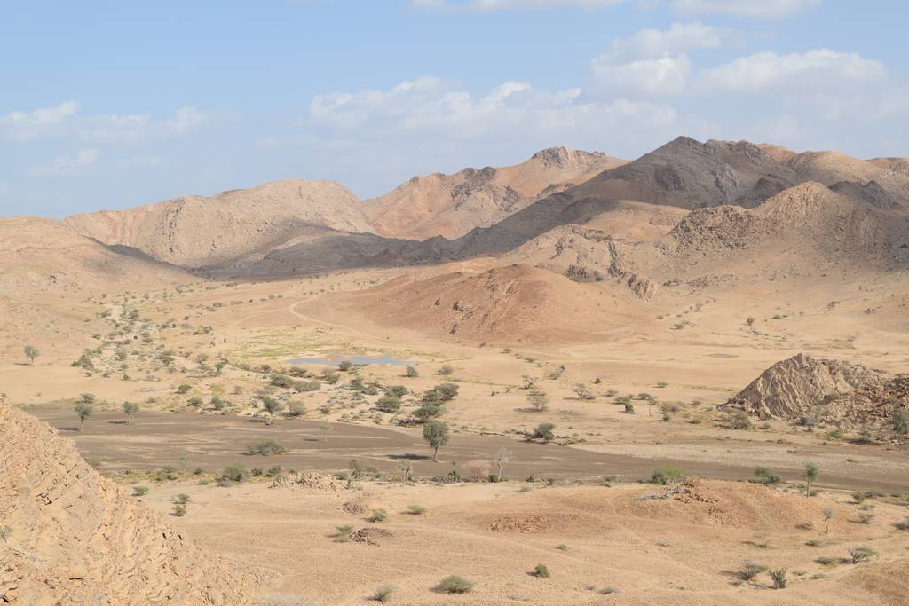
1) “Overgrazed Acacia-Prosopis pseudo-savanna.” This vegetation is located on the relict Pleistocene and Holocene alluvial terraces within and adjacent to Wadi Samad (Figure 1).
2) “Dry wadi Riparian Zone.” This vegetation represents a transition from the previous within the gravel terraces and active flood channels of wadi Samad.
3) “Wet wadi Riparian Zone.” This vegetation zone was observed more commonly in the Wadi Andam to the west of the study area, where semi-permanent pools of water in the wadi allow for a greater variety of taxa to grow (Figure 2).
4) “Euphorbia-Plocama shrubland.” This zone is characterized by shrubby vegetation surrounding small, recently active channels.
5) “Xeric slope vegetation” The vegetation is increasingly sparse on colluvium slopes and Pleistocene terraces surrounding the wadis.
6) “Anthropogenic and oasis garden vegetation” This consists of a variety of ruderal plants growing between houses in the village, fruit trees, crops, and their associated weeds (Figure 3).
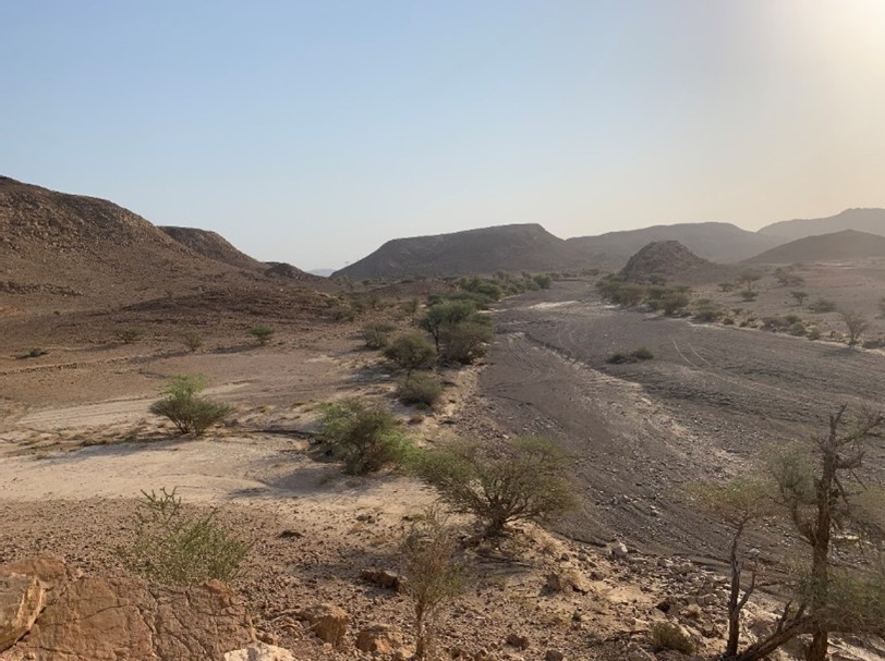 Figure 1: Example of “overgrazed Acacia pseudo-savanna” on wadi margins near Al-Khashbah.
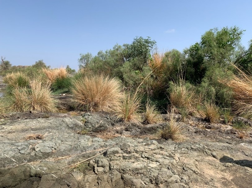 Figure 2: Example of the “Wet wadi vegetation zone” from Wadi Andam.
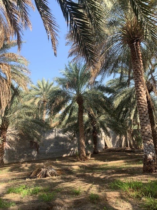 Figure 3: Example of “Anthropogenic Oasis vegetation” from a palm garden in Adam.
Regarding the current landforms in the vicinity of Al-Khashbah, the site is located at the confluence of the Wadi Samad and the Wadi Shuway’i. Both are endorheic hydrosystems with ephemeral streams. The Wadi Samad is a major hydro system of the Hajar Mountain’s southern piedmont. Its watershed starts within the al Hajar ash Sharqi system, characterised by a homogeneous ophiolite lithology (gabbro, dunite, harzburgite) related to the uplifted Semail ophiolites block. The Wadi Samad is about 80 km long and crosses the modern cities of al Rawdha, Samad, Al-Khashbah, Al Sudairah, Sinaw, and disappears nearby Uyun / Barzaman area in a vast playa. The Wadi Shuway’i takes its source within the Jebel Shuway’i, a small hills complex elevated around 500 and 600 meters above sea-level, made of ophiolites (gabbro, dunite, harzburgite) and basalts (dykes). It is running south before joining the Wadi Samad. Regarding the geographic and geological position of Al-Khashbah, the area is hydrological favoured for several reasons:
- The natural dam created by the Hawasina hills across Wadi Samad floodplain might artificially rise up the underground water level.
- The concentration of surface flows of the Wadi Samad in narrow gaps can locally increase the volume of shallow runoffs.
- The lithological contact between the ophiolites system and the limestones/ chert folded hills of Hawasina formation might be favourable for springs or groundwater emergence.
Three quaternary ancient alluvial accumulation landforms have been identified in Wadi Andam and Wadi Samad ranging from 1 to 3, following their topographical organisation (from the highest to the lowest) and their potential chronology. Those three main levels can be locally divided in sub-levels. The term « terrace » is used when the ancient alluvium is visibly incised in contrast to ancient alluvium, which is related to T1 for the oldest, T2 for the intermediate or T3 for the youngest ones.
- High terraces/ T1 alluvium deposits: Early-to-mid Pleistocene fluvial terraces.
- Medium terraces/T2 alluvium deposits (or extended fossilised floodplain in Wadi Samad): Late Pleistocene fluvial deposits/terraces supposedly linked to the late interglacial period between 115 000 and 90 000 BP.
- Low terraces/ T3 alluvium deposits: Holocene fluvial deposits/ terraces supposedly linked to the Holocene Pluvial Phase between 8,000 and 6,000 BP.
In the Wadi Samad, the highest terraces are well-exposed (T1), but isolated in the eastern of the valley, on the northern flank of the Jebel al Khashbah. The main part of the fossilised floodplain is occupied by T2 deposits, which consisted mainly of an alluvial sheet exceptionally incised by palaeochannels or current wadi channels (Figure 4). The topographical organization of the T2 alluvial deposits is barely visible, but the degree of desert varnish of pebbles varied greatly from T1, T2, to T3 alluvial deposits. The low terraces level/T3 deposits are located near the current wadi bank, often downcut one meter above current wadi bed. According to the first age-dating obtained, the alluvial accumulation of this level is related to higher fluvial dynamics during the Holocene pluvial period.
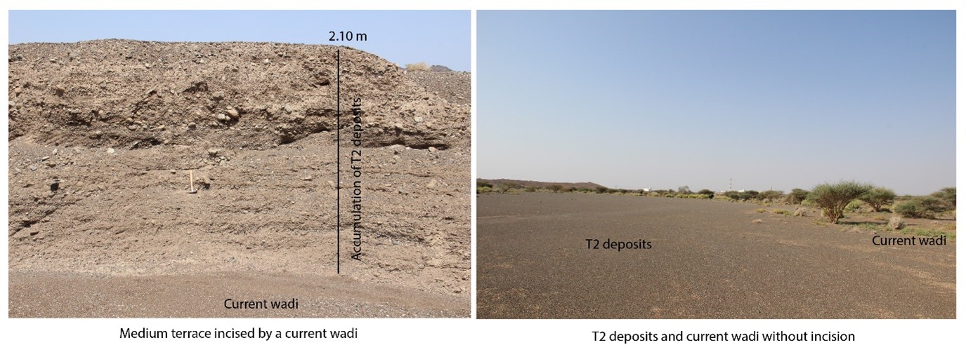 Figure 4: Medium terrace cut by a current wadi (left) and flat connection between T2 deposits and an active floodplain (right).
A map of the quaternary landforms was created for the western part of the study area. The survey of the eastern part is planned for the 2023 season (Figure 5). The map is based on Google Earth and GPS dates recorded during fieldwork. The low terraces/ T3 deposits are barely visible from the satellite imagery and can easily be recognised in the field. The map also shows the preliminary results of 2021 season’s work and will be specified and expanded in future campaigns.
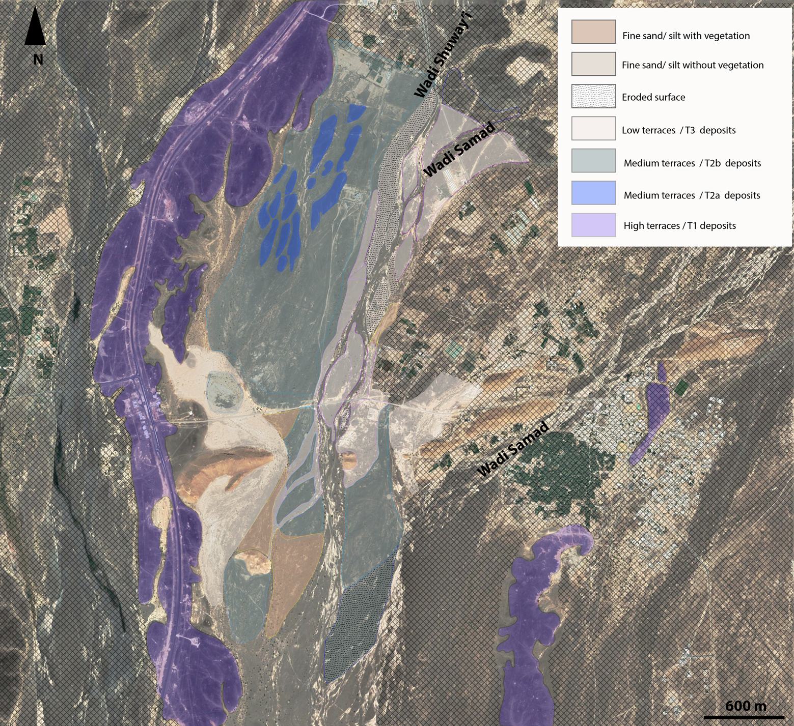 Figure 5: Preliminary map of the quaternary landforms in Al-Khashbah.
According to the units identified during the mapping of the quaternary landforms, eight soundings in several areas of the western part of Al-Khashbah were excavated with a power shovel. The aims of these soundings are 1) to refine the chronology of the alluvial accumulation of the medium terraces (T2 deposits) and the low terraces (T3 deposits), 2) to analyse the fluvial sedimentary records and 3) to analyse any potential biomarkers trapped within these fluvial archives. The soundings were selected for both catch data related to the natural dynamics and to the study of the influence of anthropogenic activities on the surrounding environment.
After the excavation, every sounding was cleaned and drawn (Figure 6).
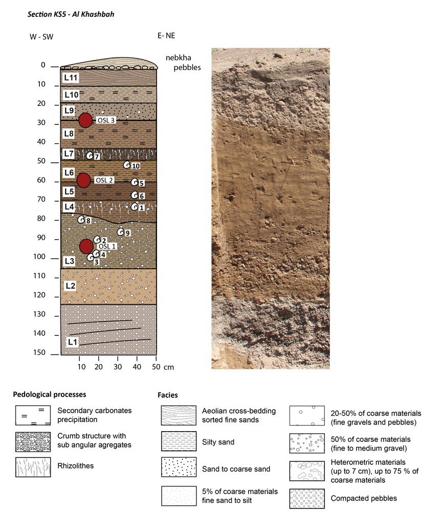 Figure 6: Sketch of a sedimentary log.
Furthermore, a multiproxy sampling strategy was employed for most of the soundings. This included systematic sampling (every 5 cm) for sedimentary and palynological analyses, selective sampling for soil analyses (according to different horizons) as well as selective sampling for anthracological and malacological analyses (according to sedimentary layers). OSL samples were collected from each sounding, as well as snails and charcoal (if present) for age dating. After sampling, all trenches were backfilled.
In October 2021, Frank Schlütz and Hermann Behling began palynological analyses of sediment archives in which information about the archaeological landscape are stored. The former vegetation cover via pollen analysis is of special interest. Species composition, vegetation density and its pattern during the Bronze Age can show, on one hand, which plant resources for available for human and animal consumption as well as for the construction of buildings and other needs. On the other hand, vegetation reflects former climatic conditions, including temperature but especially precipitation and humidity.
While the vegetation of the past is long gone, information about its composition and pattern remains stored within sediments through preserved pollen grains, charcoal and phytoliths. Pollen is produced in the flowers of the plants and spread by wind or transported by insects like bees from one flower to another. During this transport process, many of the pollen grains fall to the ground and are archived in places where sediments accumulate over time. Such places can include small depressions, basins, or wadi valleys. Pollen is very resistant against decay. Investigated under the microscope, pollen grains of different plant groups have distinct looks, allowing species to be identified millennia later (Figure 7 and Figure 8).
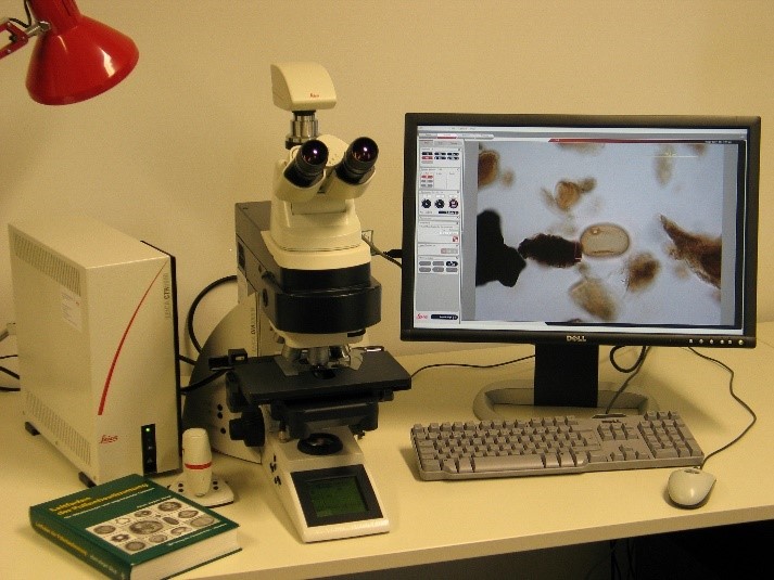 Figure 7: Microscope for pollen analyses.
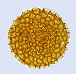 Figure 8: Pollen grain of Ruellia patula under the microscope.
Within the same sediment archives, phytoliths are also accumulated. Phytoliths are small silicate bodies produced in the plant tissues. While the organic components of leaves and stems decay over time, these mineral components can survive under favourable conditions for thousands of years like pollen grains and also help to reconstruct the former vegetation.
During fieldwork, sediment samples from about 20 sites were taken in order to test their suitability as geoarchaeological archives. Sampling occurred near to archaeological sites (Figure 9, left) as well as at a further distances (Figure 9, right), in order to find expected contrasts between more or less strongly human-influenced areas of the former landscape. To get an overview of the recent pollen and phytolith signature of varying sites and vegetation types, we collected surface samples.
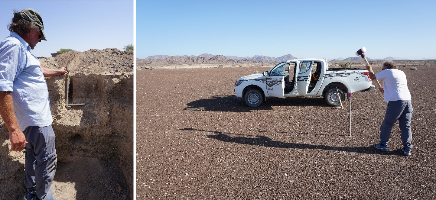 Figure 9: On-site (left) and off-site (right) sediment sampling for pollen and phytolith analyses.
To test their quality, samples will be processed in the laboratory in Göttingen this winter. The amount and quality of extracted pollen grains and phytoliths will be gauged by a microscope with 200x to 1000x magnification.
Reference material of pollen and phytoliths is needed in order to identify plants specific to Oman. For that, plant material (Figure 10) was collected during field work and with the assistance of the Oman Botanic Garden in Muscat. A reference collection of Oman pollen grains will then be produced, photographed and presented online as a useful tool to other scientists.
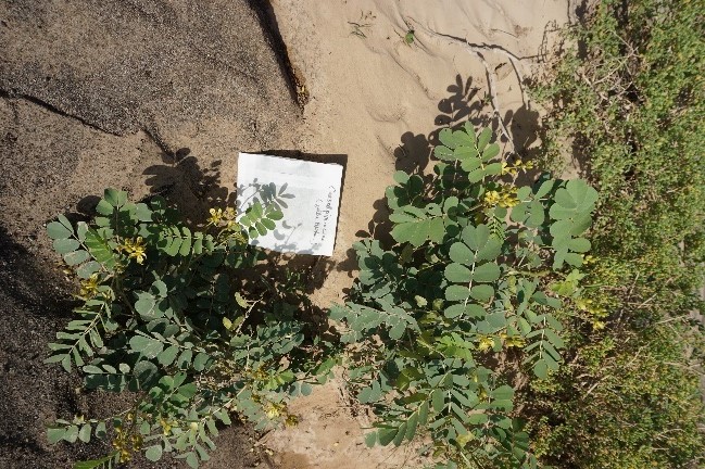 Figure 10: Collection of plant material in the field.
Besides sediments and plant material, modern dung pellets from herbivores were also collected. Dung contains pollen and phytoliths of the plants eaten by camels and goats. In addition, many specific coprophilous fungi live on such dung and produce distinct spores. Knowing these spores and the pollen grains of grazing weeds, and finding them in old sediments, allows for the identification of animal husbandry in the past. With suitable archives, we can therefore reconstruct not only the former vegetation and climate, but also the effect of human activity on the environment.
After analysing this year’s test samples and identification of suitable sediment archives, we plan to take deep sections by drilling or excavating at selected sites in springtime of 2022 to reconstruct climate and landscape change around Al-Khashbah over at least the last 5000 years.
Additional activities in September and October 2021 included the fabrication and assembly of a new recycling flotation system for processing soil samples collected by the UmWeltWandel team for the purposes of collecting charcoal for analysis. The previous flotation machine employed for past excavations at Al-Khashbah was replaced with a sturdier machine (Figure 11). The processing of samples commenced on 6 October and was conducted by Lucas Proctor from the University of Frankfurt. For the first season, ten samples were completed. These represent post-occupation fill of a large ditch (Building I), and non-archaeological sediments from the wadi and adjacent areas (KS2–KS5). Recovery from these samples was negligible, though there were some microcharcoals found throughout and plenty of gastropods that will be given to the project malacologist for analysis.
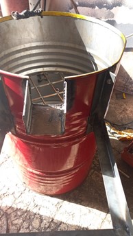 Figure 11: Construction of the new flotation system.
In spring season of 2022, the reconstruction of the Holocene floodplain continued. For this purpose, the distal part of Wadi Samad and Wadi Shuway’i floodplain was studied in order to find settling deposits or fine-grain overbanks sediments. Overbank deposits are suitable to delimit the ancient extension of Wadi Samad and Wadi Shuway’i floodplain, and ancient avulsion or migration of the main channels. In addition, those sediments may contain biomarkers, such as charcoal, pollen or snails.
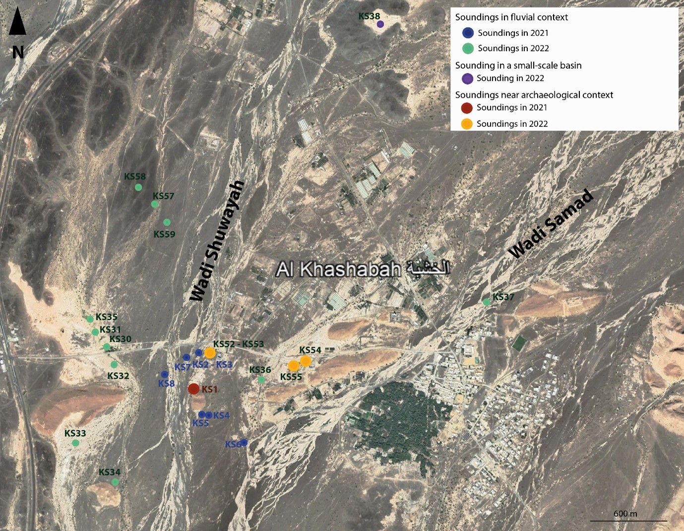 Figure 12: Localisation of the 2021 and 2022 soundings.
In total, ten soundings (from 50 cm to 4 m depth) have been opened, described, and sampled in fluvial context (KS30, 31, 32, 33, 34, 35, 36, 37, 57, 59). In those soundings, several evidence of past humid conditions were observed, such as:
- palaeosoils (KS34),
- hydromorphic features (KS30, 32, 37 (Figure 13)),
- calcrete formations (KS30, 32, 33, 36, 37),
- channels deposits with high calibre bedload (KS31, 32, 57, 36).
To better understand the evolution of Wadi Samad and Wadi Shuway’i, sedimentological samples have been collected to better characterize the nature of the sediments, their origin, and post-depositional processes. Geochronological analyses relied on snails and samples for OSL and Beryllium age-dating methods collected at the surface of the ancient alluvial sheets and inside the alluvial deposits.
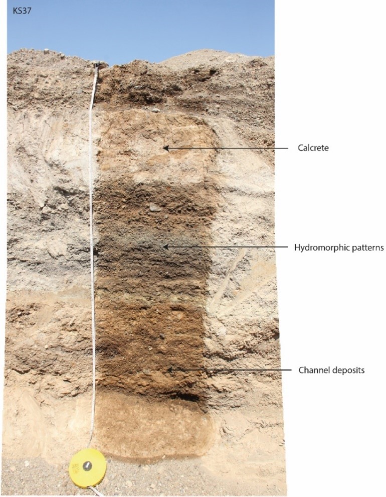 Figure 13: Picture of KS37 soundings and evidence of past humid conditions or fluvial dynamics.
KS38 (Figure 14) is a sounding located in a small structural basin surrounded by low elevations hills made of dyke’s materials (magmatic rocks). This small basin has the potential to record local environment shifts from al Khashbah, since it has a small catchment and is disconnected from the alluvial plain of Wadi Samad and Wadi Shuway’i. The basin has a clear drainage exit on its eastern side, which prevented the development of salt crust. A 3,50 m sounding was excavated to observe and analyse the depositional phases in the basin. Several samples have also been collected to better characterize the infilling phases. Pollen analyses will also be undertaken in this profile.
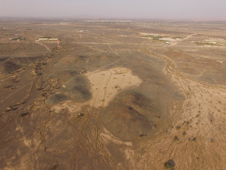 Figure 14: Areal picture of KS38.
One large trench has been opened on the southern flank of the Early Bronze Age tower structure “Building XI”, exposing two Bronze Age ditches, KS52 and KS53 (Figures 15 and 16). To better understand the function of the ditches, the formation in where they were excavated, the period of abandonment and the dynamics that lead to the infilling of those structures, seven types of sampling methods were employed. For the chronology, OSL samples and samples for radiocarbon dating (charcoals, snails, precipitation of calcium carbonates, total organic carbon) were taken. To better understand sedimentary deposition and soil formations, bulk samples (for grain size analysis and geochemical analysis) and micromorphological samples (for microscopic observation of soil processes) were collected.
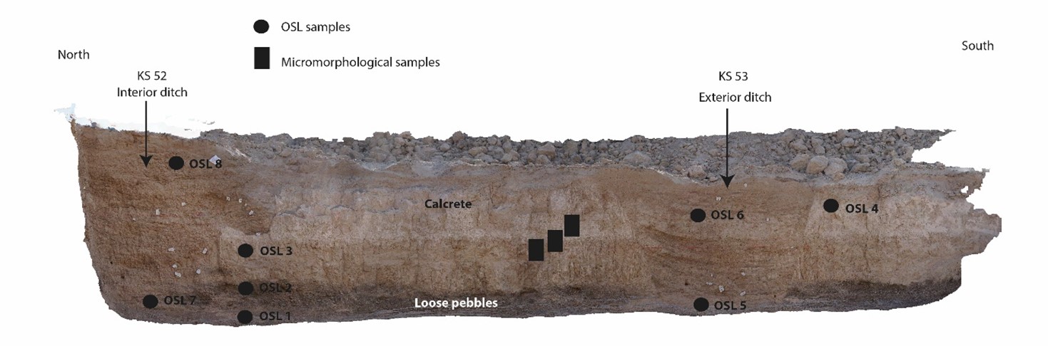 Figure 15: Interior ditch (KS52) and exterior ditch (KS53) and position of OSL samples and micromorphological samples.
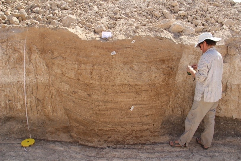 Figure 16: Exterior ditch (KS53).
In the area nearby the Early Bronze Age tower, Building VII, two soundings have been opened (KS54 and KS55). In both, fine-grain sediments and soil formation including a lot of rooting and charcoals have been observed. In those sections, at least one layer has been identified as a palaeosols (climatic forcing?) and two layers as ancient gardens. For the chronology, OSL samples and samples for radiocarbon dating were taken. To better understand sedimentary deposition and soil formations, bulk samples (for grain size analyse and geochemical analyse) and micromorphological samples were collected.
In the season of 2022 fieldwork activities related to the archaeobotany subproject of the larger UmWeltWandel included three primary activities: 1) continued qualitative survey of modern vegetation in the vicinity of Al-Khashbah village; 2) collection and processing via flotation and dry sieving of bulk sediment samples from geomorphological soundings in support of the archaeobotanical and archaeomalacological components of the UmWeltWandel Project, and 3) targeted excavation and sampling of probable pyrotechnic features previously identified by the Al-Mudhaybi Regional Survey Project for charcoal sample collection.
Regarding the vegetation survey, attention was given to expanding and refining identifications of plant species found on the margins of the Wadi Samad. Several identifications from the 2021 campaign were updated, including Acacia ehrenbergiana and Lycium shawii thanks to these species being in flower in February-March. A planned systematic survey of tree species along an east-west transect in Wadi Samad was begun, and will continue in 2023. This survey is intended to document morphometric measurements, mostly of Acacia tortilis, including crown height and area, trunk diameter, and primary branch diameter (Figure 17). These measurements, in connection with the targeted collection of wood samples, will provide information on how variability in wood anatomy is affected by growth history.
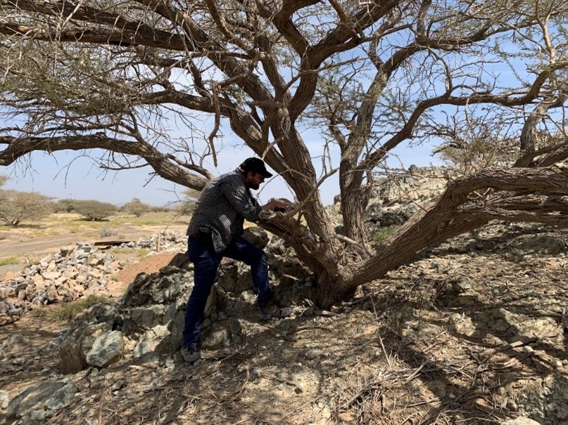 Figure 17: Measuring Acacia tortilis branch width.
Continuing from the first campaign of autumn 2021, bulk sediment samples ranging in size from 5–15 L were collected from stratigraphic layers of interest in eight soundings opened by the UmWeltWandel team during the 2022 field campaign (Figure 18). Bulk samples were processed via sieving in non-anthropogenic contexts where charcoal and seeds were unlikely to be deposited with the goal of collecting snail shells large enough for analysis. These included bulk samples processed through dry-sieving with a ca. 4–5 mm mesh from KS30, KS32, KS34, and KS38 from levels where greater abundances of snail shells were observed. Collection of snails from bulk sediments is necessary in order to perform a statistically meaningful assessment of snail abundance, which can give insights into the degree of vegetation cover and shade present in the past. In total, 50 buckets of sediment, or >240 L of sediment, were processed, yielding charcoal and snails for laboratory analysis in Germany (Figures 18 and 19).
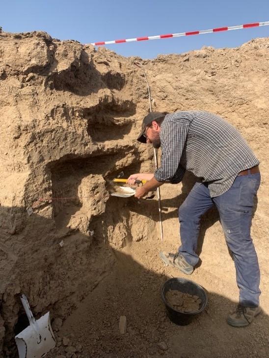 Figure 18: Collection of bulk sediment samples for flotation from KS54.
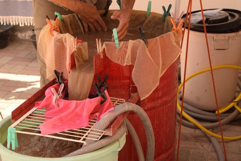 Figure 19: Flotation of bulk sediment samples in the expedition house.
Finally, limited excavations at two sites, LZQ1 (Figure 20) and MTL2 (Figure 21), located near the villages of Lizq and Al-Mutayla respectively, were undertaken with the goal of finding Neolithic charcoals within in situ stone fireplaces. The two sites were selected in consultation with the Al-Mudhaybi Regional Survey Project of Stephanie Döpper from the University of Frankfurt as likely locations for possible preserved Neolithic fireplaces, based on their morphology and diagnostic surface finds. Excavation of LZQ1 consisted of a 1 x 2 m test trench bisecting the selected feature along a E-W orientation. Excavations continued to a depth of ca. 10 cm, but found no intact feature below the surface, few artifacts and no charcoal. Excavations at MTL2 also consisted of a 1 x 2 m test trench oriented along an E-W line, but was intended to expose an area just at the entrance of a 2-meter wide “C”-shaped structure that has parallels with probable Neolithic structures identified elsewhere in the region. This area had small (20 x 20 cm), irregular stone clusters that had the appearance of fireplaces. Upon excavation, however, these clusters turned out to only contain surface scatters laying on top of aeolian dust, with no evidence of an intact surface or fireplace. No charcoal was recovered, so excavations were terminated at that point.
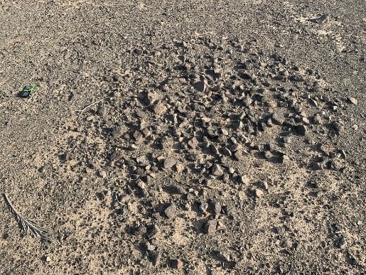 Figure 20: Possible fireplace at LZQ 1, prior to excavation.
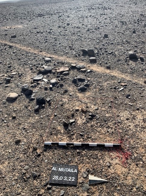 Figure 21: Stone installation at MTL2 prior to excavation.
In 2022, pollen traps were set up at various locations to understand the current pollen occurrence and transport in the area around Al-Khashbah (Figure 22). These are filled with glycerine, which prevents the pollen material that has already been carried in by the wind from being washed out again by rainfall. The pollen traps are to be collected again during field work in 2023 and thus represent the pollen input over a whole year. Additionally, surface samples were taken from various currently water-bearing lakes in the area. We hope that these samples will also give us an overview of today's pollen input, in order to be able to estimate the pollen input during the Bronze Age based on possible deviations in the pollen composition in the sediment archives. About 50 additional plant samples were collected on site to further expand the pollen reference collection.
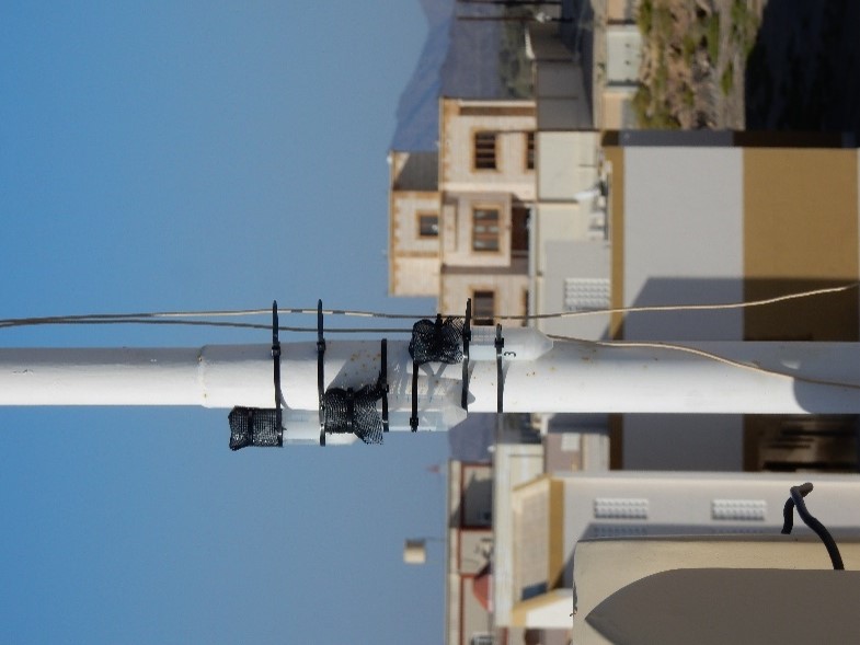 Figure 22: Installation of pollen traps at the housing in Al-Khashbah.
In addition to sampling the already mentioned soundings (KS30, 32, 37, 38, 54 and 55) and ditches (KS52 and 53), fieldwork was extended to other areas. In the central part of the Al-Hajar mountains, not far from Sint, there are a several of sediment-filled sinkholes close together. The largest is commonly referred to as Sint-Polje. There, at the investigation site of another working group from the University of Brno from the Czech Republic, further sediment material could be drilled in several profiles (Figure 23). If we find a promising number of pollen grains in these samples, a possible cooperation is planned with regard to the palynological investigation of Sint Polje. Another sampling area was the Sharqiyah Sands to the east of Al-Khashbah. There, samples were taken from places with lime deposits, which indicate a high-water level in the desert (Figure 25). In this way, it may have been possible to find places where there used to be standing water with a good pollen preservation.
In addition, mud bricks (KS43-50) were sampled as possible archives of pollen and phytoliths.
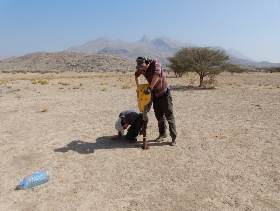 Figure 23: Drilling at Sint-Polje site.
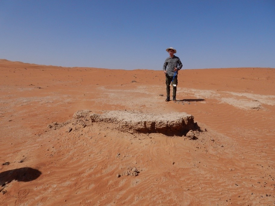 Figure 24: Lime deposits at Sharqiyah Sands.
The 2022 field campaign regarding malacology was mainly used to familiarise with the terrain and environmental conditions. Terrestrial and aquatic snails were collected at various sites (recent and fossil). We also investigated where and under which conditions living snails can be found in order to deduce living conditions in the past. Some aquatic snails were found living in the Falaj, while terrestrial snails were not found living despite intensive search.
The first recent snails brought from the field have already been used as comparative material to test diagenetic ageing. For this purpose, the snails were cleaned and crushed with a mortar. Subsequently, XRD, IRMS, ICP-OES and Raman analyses were carried out on them.
In addition to the snails, calcrete found in various locations was also analysed using IRMS. Hopefully, the isotopic data can be used to reconstruct the climatic conditions that prevailed during its deposition. Besides the calcrete, travertine was also found and sampled, which is now to be dated by means of U/Th analysis at the University of Mainz and which will then also contribute to the climate reconstruction. For this purpose, three big pieces of rock were cut from the travertine and well packed so that the original stratification is preserved, as this is important for the depositional history.
Another experiment was set in progress: Two temperature loggers were placed under water at different locations. These record the prevailing water temperature signal every two hours, so that when the data is read out in a year's time (field campaign 2023), the exact temperature profile of the water over a year is recorded. This is useful because the actualism principle can then be applied to compare the climate then with today and test whether the shells, which are mainly used for temperature recalculation, have recorded a reasonably meaningful signal. Also, a water sample is taken every 3 days at the locations where the loggers are placed, which is then analysed for δ18O at the Max Planck Institute for Chemistry. The aim is to check how stable the isotope of the water is, i.e., how the temperature changes over the year and how precipitation affects it.
Two temperature and humidity loggers were also placed. Like the water trackers, they will measure T and humidity every two hours so that it can be calculated how often during the year the conditions are favourable for terrestrial snails (T range: 17 - 32°C plus humidity between 75-95%) to excrete their shells. Here, too, the actualism principle will be applied.
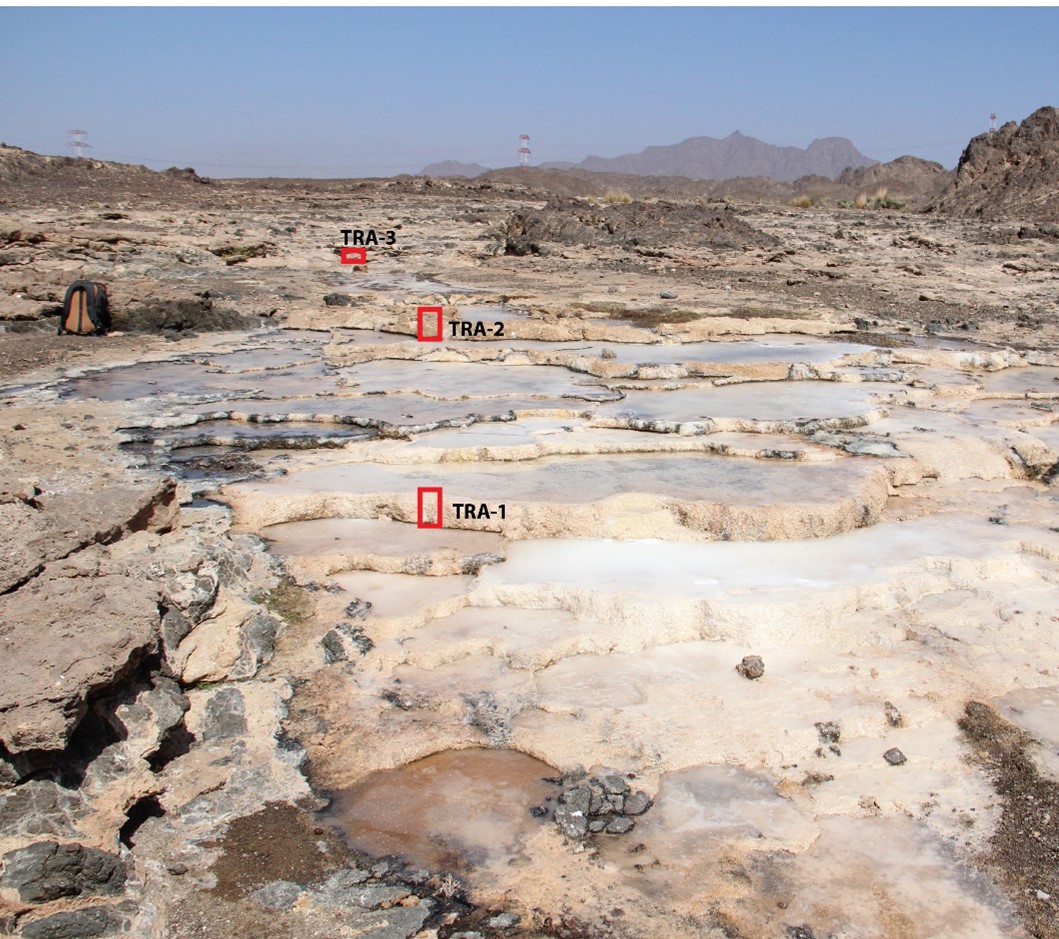 Figure 25: Travertine with sample locations.
Fieldwork activities – Seasons 2023:
The final field season lasted from 7 January to 17 April 2023. It resulted in the collection of further samples of sediment, rock, charcoal, snail, plant, pollen, and water for laboratory analysis in Germany. The expedition’s teams included Lucas Proctor, Katharina Schmitt, Tara Beuzen-Waller, Dana Pietsch, Antonia Reinhardt, Madita Walter, Viktor Kurz, Nico Rogalski, Justus Schünemann, Jonathan Behling, Jakez Moreau and Conrad Schmidt.
Four areas sections that were originally excavated in 2021 and 2022 were reopened for complementary study of the stratigraphy and taking additional soil samples: KS3, KS5, KS53 and KS54. Additionally, a further four new soundings were opened near archaeological sites: KS76 (south of Building I, VII, VIII and IX), KS77 (near Building II), KT10 (near Building II), KT11 (near Qabrayn tower).
Three areas were survey and mapped to locate and describe relict and modern fluvial formations. These are included the vicinity of Al-Khashbah, Wadi Samad East, and Safrat Al-Khashbah (Figure 26).
Finally, much of the 2023 field campaign was dedicated to completing the geochronological framework for the fluvial and soil formations around Al-Khashbah. Twenty previously excavated sections were reopened to take additional OSL samples, while a further twenty samples were collected from the aforementioned sections first opened and studied this year.
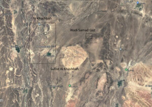 Figure 26: Location of the three areas were detailed geomorphological mapping has been conducted in 2023.
Snails were extracted from the profiles for geochemical analysis. To do this, the profiles were examined for the presence of well-preserved material. The selected snails were noted in the profile drawing and safely packed in Eppendorf cylinders for later sampling in Germany. Recent specimens of the M. tuberculata species were found, while recent Zootecus insularis specimens could not be traced. In total, 38 snails were collected. Bivalves were also sampled to establish an additional climatic archive. Various shells were selected from materials collected during the 2015 to 2019 excavations at Al-Khashbah. The largest fragments were chosen, along with two fully intact shells. The majority of the shells were Pectinida. Additionally, recent material of as many species as possible were collected from the beaches of Sifa and Qurum.
In 2022, four trackers were installed at different locations to record various environmental signals. One of the trackers, which measured temperature and relative humidity every two hours (Figure 27), was buried approximately ten centimeters below surface. Another tracker, measuring the same parameters, was placed in a tree above the buried tracker. The remaining two trackers, which measured only temperature (also every two hours), were placed in a 19 m deep well and at an access point to the falaj of Al-Khashbah. After one year, the trackers were retrieved for analysis.
Water samples were collected regularly in Al-Khashbah over the course of the previous year, with one sample taken every third day from a single location. In addition, individual samples were collected from various water bodies such as aflāj, wadis, and the sea. In total, more than 140 water samples were collected.
In addition, sediment samples were collected for X-ray fluorescence analysis in order to study land pollution in the past.
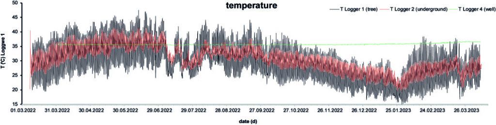 Figure 27: Temperatures recorded by the trackers.
During the 2023 field campaign, three potentially promising sites (KS3, KS5 and KS54) were re-sampled to gain more sediment material for pollen-, micro- and macro-charcoal analyses. Two new soundings KS76 (0–260cm) and KS77 (0–150cm) were sampled around the archaeological excavations in Al-Khashbah.
However, the main focus of this campaign was the documentation and description of the existing vegetation. Several approaches have been pursued to gain a holistic view on the modern pollen flora and pollen rain in the area as a basis to estimate the pollen input and interpret pollen concentrations during the Bronze Age. At fourteen locations, both old and new (AK, AS1, OS, WSR), surface samples were collected and qualitative vegetation surveys conducted to give an overview of the modern pollen input. Another valuable tool to track the pollen transportation and input over a whole year are the pollen traps. Several were installed at various locations within the study area during field work in 2022 (Figure 22), and, after one year, of these, fifteen out of eighteen total traps were found undestroyed and recovered for further analyses in Germany.
The most comprehensive task consisted of collecting more plant samples from different habitats (wadi vegetation, oasis vegetation, mountain vegetation, coastal vegetation, desert vegetation) for expanding the pollen reference collection (Figure 28). In total, over 130 additional plant samples were taken. Currently, this newly established pollen reference collection for Oman includes more than 400 different pollen species.
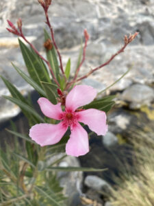 Figure 28: Nerium oleander in vicinity to new site AS1.
In 2023, the program of surveying and sampling modern local vegetation in the vicinity of Al-Khashbah was continued. For the archaeobotany subproject, this included the further collection of wood samples from a variety of tree species (Figure 17) and the experimental burning of samples to produce reference charcoal. These efforts were built upon work completed in the 2021 and 2022 field seasons and have produced a reference dataset of major tree species commonly found in the southern Hajar foothills region to be used in ongoing analyses of wood charcoal from excavations.
Over the course of the campaign, the collection of charcoal samples for anthracological and carpological laboratory analysis was continued. Flotation samples were processed on-site using a water-recycling flotation system (Figure 19), while charcoal samples were collected by hand or through sieving. These samples were sourced from a variety of contexts within the study area. Charcoal and flotation samples were collected from geomorphological sections and soundings opened by the UmWeltWandel project with the primary objective of building a set of radiocarbon dates for high-resolution age-depth models (Figure 18). Several rich charcoal deposits from excavations of a nearby Neolithic site, KHS-A (Figure 29), were also sampled, which, when compared with Bronze Age and later period samples from Al-Khashbah, will result in a long-term, diachronic dataset tracking vegetation change over the course of Holocene.
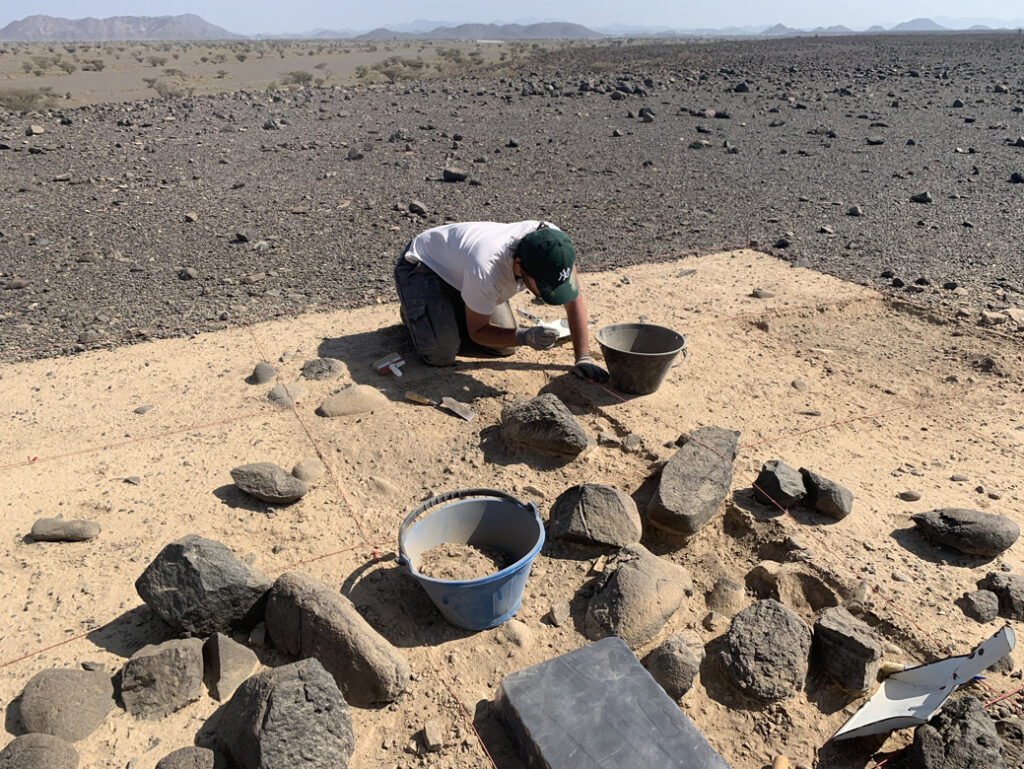 Figure 29: Excavations of Neolithic features on a terrace north of Al-Khashbah.